

The Himalayan range encompasses about 15,000 glaciers, which store about 12,000 km3 of freshwater. The 70 km-long Siachen Glacier at the India-Pakistan border is the second longest glacier in the world outside the polar region. Some of the other more famous glaciers include the Gangotri and Yamunotri (Uttarakhand), Nubra, Biafo and Baltoro (Karakoram region), Zemu (Sikkim) and Khumbu glaciers (Mount Everest region).
The higher regions of the Himalayas are snowbound throughout the year, in spite of their proximity to the tropics, and they form the sources for several large perennial rivers, most of which combine into two large river systems:
* The western rivers combine into the Indus Basin, of which the Indus River is the largest. The Indus begins in Tibet at the confluence of Sengge and Gar rivers and flows southwest through India and then through Pakistan to the Arabian Sea. It is fed by the Jhelum, the Chenab, the Ravi, the Beas, and the Sutlej rivers, among others.
* Most of the other Himalayan rivers drain the Ganga-Brahmaputra Basin. Its two main rivers are the Ganga and the Brahmaputra and the Yamuna, among other tributaries. The Brahmaputra originates as the Yarlung Tsangpo River in western Tibet, and flows east through Tibet and west through the plains of Assam. The Ganga and the Brahmaputra meet in Bangladesh, and drain into the Bay of Bengal through the world's largest river delta.[2]
The eastern-most Himalayan rivers feed the Ayeyarwady River, which originates in eastern Tibet and flows south through Myanmar to drain into the Andaman Sea.
The Salween, Mekong, Yangtze and the Huang He (Yellow River) all originate from parts of the Tibetan plateau that are geologically distinct from the Himalaya mountains, and are therefore not considered true Himalayan rivers. Some geologists refer to all the rivers collectively as the circum-Himalayan rivers.[3] In recent years, scientists have monitored a notable increase in the rate of glacier retreat across the region as a result of global climate change.[4] Although the effect of this will not be known for many years, it potentially could mean disaster for the hundreds of millions of people who rely on the glaciers to feed the rivers of northern India during the dry seasons.[5]
Lakes
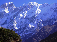
A high Himalayan lake at an altitude of around 5,000 metres Sikkim, India
The Himalaya region is dotted with hundreds of lakes. Most lakes are found at altitudes of less than 5,000 m, with the size of the lakes diminishing with altitude. The largest lake is the Pangong Tso, which is spread across the border between India and China. It is situated at an altitude of 4,600 m, and is 8 km wide and nearly 134 km long. A notable high (but not the highest) lake is the Gurudogmar in North Sikkim, at an altitude of 5,148 m (17,100 ft) (altitude source: SRTM). Other major lakes include the Tsongmo lake, near the Indo-China border in Sikkim, and Tilicho lake in Nepal in the Annapurna massif, a large lake in an area that was closed to tourists until recently.
The mountain lakes are known to geographers as tarns if they are caused by glacial activity. Tarns are found mostly in the upper reaches of the Himalaya, above 5,500 metres. For more information about these,
No comments:
Post a Comment